
- Видео 58
- Просмотров 6 065 355
PacificTWC
Добавлен 26 июн 2013
The Pacific Tsunami Warning Center (PTWC) is one of the United States' two tsunami warning centers operated by its National Weather Service to monitor the world's oceans 24/7 for tsunami hazards, respond to tsunamis with appropriate alerts, develop new tsunami hazard detection techniques, and inform emergency managers and the public about their operations and tsunami science. PTWC is primarily responsible for protecting Hawaii, U.S. Pacific territories, and nations participating in the Pacific and Caribbean tsunami warning systems. For more information about PTWC please see our official site at tsunami.gov/ (link below).
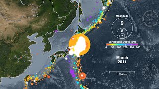
120 Years of Earthquakes and Their Tsunamis: 1901-2020
This animation shows every recorded earthquake in sequence as they occurred from January 1, 1901, through December 31, 2020, at a rate of 1 year per second. The earthquake hypocenters first appear as flashes then remain as colored circles before shrinking with time so as not to obscure subsequent earthquakes. The size of each circle represents the earthquake’s magnitude while the color represents its depth within the earth. This animation also highlights significant tsunamis generated by some of these earthquakes. When the following earthquakes appear they will also have their tsunami’s “energy map” that shows each tsunami's maximum modeled wave heights on the open ocean:
8.8 - Ecuador-Col...
8.8 - Ecuador-Col...
Просмотров: 158 412
Видео


Tsunami Forecast Model Animation: Three Tsunamis in One Day From the Tonga-Kermadec Subduction Zone
Просмотров 38 тыс.3 года назад
The Tonga-Kermadec Subduction Zone is a convergent boundary where the Pacific is subducted beneath the Australian Plate. It extends northeastward from New Zealand, through the Kermadec and Tonga Islands, and terminates just south of the Samoan Islands, covering a distance of about 2800 kilometers or 1800 statute miles. This boundary is also a source of large, shallow, undersea megathrust earthq...

40 Years of Earthquakes in the Contiguous United States: 1980 - 2020
Просмотров 184 тыс.4 года назад
Every state and territory of the United State of America experiences earthquakes. In the contiguous states most of these earthquakes do not pose a tsunami risk as they do not lift or drop the seafloor. They are either too small, too far from a body of water, or move the underlying rock sideways. For these reasons two widely-felt earthquakes in March of 2020 also failed to generate tsunamis: the...
30 Years of Earthquakes in Japan: 1990 - 2019
Просмотров 32 тыс.4 года назад
The nation of Japan lies above a tectonic plate boundary called a “subduction zone” where the Pacific and Philippine Sea Plates grind beneath the Eurasian Plate. This type of plate boundary can create volcanoes, such as Japan’s many volcanoes including Mt. Fuji. Subduction zones can also generate megathrust earthquakes beneath the seafloor that cause devastating tsunamis. Many such earthquakes ...
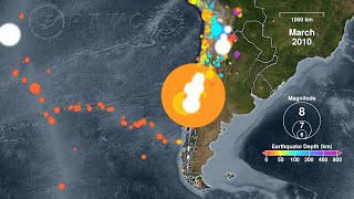
20 Years of Earthquakes in Chile: 2000 - 2019
Просмотров 12 тыс.4 года назад
The nation of Chile lies above a tectonic plate boundary called a “subduction zone” where the Nazca and Antarctic Plates grind beneath the South American Plate. This type of plate boundary can create mountain belts and volcanoes, such as those that make up the Andes that stretch the entire length of the South American continent. Subduction zones can also generate megathrust earthquakes beneath ...

Puerto Rico Earthquake Sequence: December 2019 - January 2020
Просмотров 28 тыс.4 года назад
The start of 2020 saw some significant earthquake activity in the Puerto Rico region. A M6.4 earthquake struck the southern coast of Puerto Rico on January 7, killing at least one person and damaging many structures including the homes of thousands of people. It also produced a small, non-hazardous tsunami. It was preceded by a series of foreshocks in late December and followed by a sequence of...

Earthquakes of the Caribbean: 2001 - 2020
Просмотров 28 тыс.4 года назад
January 2020 saw some significant earthquake activity in the Caribbean Sea region. A M6.4 earthquake struck the southern coast of Puerto Rico on January 7 and generated a small, non-destructive tsunami. An active swarm of aftershocks continues today (January 30, 2020). A much larger M7.7 earthquake occurred between Cuba and Jamaica on January 28 and thankfully did not generate a damaging tsunam...

Five Years of Earthquakes in Southern Alaska: 2015 - 2019
Просмотров 4,5 тыс.4 года назад
Alaska lies above a tectonic plate boundary called a “subduction zone” such that the Pacific Plate grinds beneath the North American Plate. This type of plate boundary can create volcanoes, such as Redoubt, Augustine, and Katmai. Subduction zones can also produce megathrust earthquakes with large vertical motions that cause devastating tsunamis, such as the M9.2 Great Alaska Earthquake that str...

Earthquakes of Indonesia: 2004 - 2019
Просмотров 54 тыс.4 года назад
On 26 December 2004 the third-largest earthquake ever recorded struck the coast of Sumatra, Indonesia, with a magnitude of 9.1. It generated the deadliest tsunami in history and one of the deadliest natural disasters killing nearly 228,000 people in 14 countries. Indonesia lies above a tectonic plate boundary called a “subduction zone” where the Indo-Australian Plate grinds beneath the Eurasian...
Earthquakes of Alaska: 1918 - 2019
Просмотров 41 тыс.4 года назад
The M7.1 earthquake that occurred under Anchorage, Alaska, on November 30, 2018, was the largest earthquake to impact the city in 54 years. It was not, however, the largest recorded earthquake there. That distinction goes to the March 28, 1964, M9.2 Great Alaskan Earthquake (a.k.a. the Good Friday Earthquake) that struck the region as the largest earthquake ever recorded in North America, and t...
Earthquakes of the Caribbean: 1918 - 2019
Просмотров 123 тыс.4 года назад
The M6.0 earthquake that occurred near Puerto Rico on September 24, 2019, was the largest earthquake to strike the U.S. territory in five years. It was not, however, the largest recorded earthquake there. That distinction goes to the July 7, 1943, M7.7 earthquake that thankfully did not generate a tsunami. Other earthquakes, and sometimes the landslides they cause, have produced tsunamis throug...
Earthquakes of Cascadia: 1979 - 2019
Просмотров 61 тыс.4 года назад
The widely-felt M6.3 earthquake of August 29, 2019 on the Blanco Fracture Zone was only the most recent of many moderate-size earthquakes to strike this region off of the Oregon coast. As this animation shows, such earthquakes are common along the boundaries of the Juan de Fuca plate with the Pacific Plate, which also includes the Juan de Fuca Ridge, the Gorda Ridge, and the Mendocino Fracture ...
Earthquakes of California: 1989 - 2019
Просмотров 69 тыс.5 лет назад
On July 5, 2019, the largest earthquake to strike California in 20 years occurred near the town of Ridgecrest with a moment magnitude of 7.1 following a magnitude 6.4 foreshock on the previous day. The National Tsunami Warning Center (NTWC) in Palmer, Alaska, has the primary responsibility for determining whether earthquakes in the continental United States, including California, pose a tsunami...
Kīlauea Volcano’s Earthquakes and Eruptions: April - August, 2018
Просмотров 12 тыс.5 лет назад
The NWS’s Pacific Tsunami Warning Center (PTWC) mitigates tsunami hazards in Hawai‘i produced by large, distant earthquakes throughout the Pacific Ocean, but PTWC also issues warnings for tsunamis generated by earthquakes within the State of Hawai‘i itself. The last such dangerous tsunami was generated by a 7.7 magnitude earthquake on the Big Island of Hawai‘i in 1975. Small earthquakes generat...
Earthquakes of Hawaiʻi Island: 2013 - 2018
Просмотров 6 тыс.5 лет назад
This animation shows earthquakes on or near the Big Island of Hawaiʻi in sequence as they occurred from January 1, 2012, through December 31, 2018. Prior to 2018 the animation proceeds at a speed of one month per second, but shifts into a “slow motion” rate of one week per second for 2018 to better show the extraordinary seismic activity associated with that year’s new eruptive activity on Kīla...
Earthquakes of the Hawaiian Islands: 1973 - 2018
Просмотров 8 тыс.5 лет назад
Earthquakes of the Hawaiian Islands: 1973 - 2018
Earthquake Animation: Kīlauea Caldera - 1 April to 31 August 2018
Просмотров 6 тыс.5 лет назад
Earthquake Animation: Kīlauea Caldera - 1 April to 31 August 2018
Context: a graphical comparison of earthquake energy release in Hawaiʻi
Просмотров 6 тыс.6 лет назад
Context: a graphical comparison of earthquake energy release in Hawaiʻi
Tsunami Forecast Model Animation: Aleutian Islands 1957
Просмотров 22 тыс.7 лет назад
Tsunami Forecast Model Animation: Aleutian Islands 1957
Perspective: a graphical comparison of earthquake energy release
Просмотров 40 тыс.7 лет назад
Perspective: a graphical comparison of earthquake energy release
Tsunami Forecast Model Animation: Sumatra 2004
Просмотров 245 тыс.7 лет назад
Tsunami Forecast Model Animation: Sumatra 2004
Earthquakes of the First 15 Years of the 21st Century
Просмотров 496 тыс.7 лет назад
Earthquakes of the First 15 Years of the 21st Century
Tsunami Forecast Model Animation: Lisbon 1755
Просмотров 189 тыс.7 лет назад
Tsunami Forecast Model Animation: Lisbon 1755
Tsunami Forecast Model Animation: Samoa 2009
Просмотров 26 тыс.7 лет назад
Tsunami Forecast Model Animation: Samoa 2009
Tsunami Forecast Model Animation: Chile 1960
Просмотров 233 тыс.8 лет назад
Tsunami Forecast Model Animation: Chile 1960
Tsunami Forecast Model Animation: Aleutian Islands 1946
Просмотров 34 тыс.8 лет назад
Tsunami Forecast Model Animation: Aleutian Islands 1946
Tsunami Forecast Model Animation: Alaska 1964
Просмотров 73 тыс.8 лет назад
Tsunami Forecast Model Animation: Alaska 1964
Tsunami Forecast Model Animation: Japan 2011
Просмотров 222 тыс.8 лет назад
Tsunami Forecast Model Animation: Japan 2011